The National Weather Service has issued a winter weather advisory for most of southeast lower Michigan that will go from noon today until midnight tonight. They are generally calling for 3-5 inches for most of the area, with the heaviest snowfall coming between 3pm and 9m where 2-3 inches is expected to fall during this time period.
This morning’s model runs have all trended towards favoring a storm track that is a little further west than previously anticipated. This will cause the area of precipitation to also move further west, thus covering more of Michigan and for a longer period of time.
Looking at the total precipitation map below, you can see that most of southeast lower Michigan is covered by an area of expected precipitation that is in between 0.25-0.50 of an inch. Since along the Ohio border is expecting around 0.32 of an inch of precipitation, then I would expect about the same or slightly less for areas in Macomb County. Considering the fact that this will be a drier snowstorm, we should expect the snow ratio to be higher than the traditional 10:1 (10 inches of snow for every 1 inch of liquid precipitation). Thus, we could expect a ratio anywhere from 12:1 to 15:1 which would give us about 3 to 5 inches of snow.
12:1 à 12*0.25 = 3.00 to 12*0.35 = 4.20 (3.00 to 4.20 inches)
15:1 à 15*0.25 = 3.75 to 15*0.35 = 5.25 (3.75 to 5.25 inches)
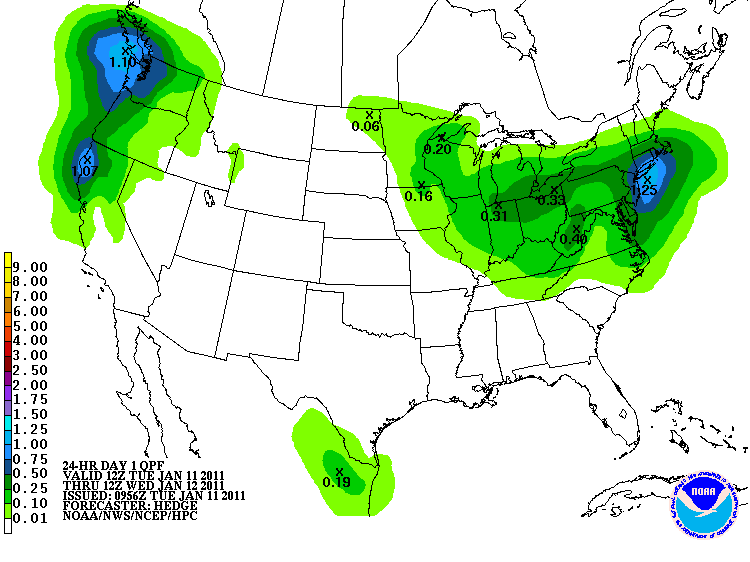 The image above shows the total precipitation expected to fall from 7am Tuesday to 7am Wednesday. This image is courtesy of HPC. Most of southeast lower Michigan is in the area expecting 0.25-0.50 of an inch of precipitation.
Radar image at 12:28pm showing the snow to our southwest. Image courtesy of NWS.
Anyone interested can click here to see the forecasted radar that shows the expected precipitation from 10am this morning to 7pm Wednesday evening. Enjoy the snow!
No comments:
Post a Comment