Saturday, December 31, 2011

High Winds and Cold Temperatures…also wettest year in Detroit History


A system that is currently over the northern plains will make its way into the Metro Detroit area on Sunday.  This system will bring us mostly rain with some snow, but the bigger concern is the high winds and colder temperatures that will move in behind the cold front.

Currently, there are two areas of energy (aka…shortwave or upper-level lows) in the upper atmosphere, with the main feature over the northern plains and the secondary feature in Canada.  These two shortwaves will combine together over the Great Lakes region causing the surface low to rapidly deepen.  This will result in a fairly strong low pressure system that will move through northern Michigan bringing high winds and cold air behind it.

The first image below is a surface map for Sunday morning at 8am.  The surface map is forecasting the center of the primary low (the red L) to be approaching the northern portion of Lake Michigan while the secondary low will be positioned near the Hudson Bay in Canada.  Metro Detroit will be in the warm sector (south of the warm front and east of the cold front) with southerly winds bringing in warmer air.  Because of this, the precipitation that we receive on Sunday will only be rain.  

 The above image is a forecast surface map for Sunday morning at 8am.  This image is courtesy of HPC.

The second image below is a surface map for Sunday evening at 8pm.  This surface map shows that the two low pressure centers combined into a single low pressure system.  This is due to the two shortwaves combining in the upper atmosphere, and the result is a rapidly strengthening (deepening) system.  The cold front will be well off to our east allowing cold air (e.g. cold air advection) to pour into our region thanks to strong west/northwest winds.  

  The above image is a forecast surface map for Sunday evening at 8pm.  This image is courtesy of HPC.

When looking at surface maps, a sign that there will be strong winds is when you see the black lines (isobars) so close together.  Isobars represent lines of equal pressure.  Isobars become so close together when there is a large difference in pressure over a relatively short distance.  The surface low just north of Michigan is forecasted to be quite low at 992mb, and if you look at eastern Montana, you will see a strong area of high pressure with the center forecasted to be at 1040mb.  That is a difference of 48mb of pressure over a short distance!  Now the atmosphere does all that it can to keep itself balanced or equal.  With such a large difference in pressure, winds will blow much stronger in a direction from the high pressure towards the low pressure in an attempt to equalize the pressure.  This is why we will have very strong winds tomorrow.  Currently we are under a high wind watch.  For us to have a high wind warning, sustained winds will have to be at least 40mph or higher, or wind gusts will have to reach 58mph or higher.  I do not believe we will receive a high wind warning but we will most likely be under a wind advisory on Sunday with sustained winds around 25-30mph with wind gusts possibly reaching 50mph.  These strong winds will help rush in cold arctic air resulting in Monday and Tuesday only reaching the 20s for highs (Tuesday might only reach upper teens).  This cold air won’t last very long as a upper ridge will move into our area bringing the temperatures back up near 30F on Wednesday.  So unfortunately there could be some power outages on Sunday into Monday morning just in time for the January bowl games!  Hopefully that doesn’t happen.

2011 Wettest Year in Detroit History
Finally, it is worth mentioning that 2011 will go down as the wettest year in Detroit history, breaking the old record that was set back in 1880.  Breaking a record that has stood for 130 years is pretty impressive!  The Detroit area received 47.70 inches of precipitation (3 tenths of an inch away from 4 feet) barely beating the 1880 record of 47.69 inches.  Below are a few interesting points about the 2011 record.

-2011 47.70 inches of precipitation is 14.60 inches above the annual average of 33.09 inches
-2011 had the wettest autumn ever and the second wettest spring ever
-November 2011 was the wettest November ever (6 inches of rain)
-July 2011 was the second wettest July ever (7.66 inches of rain)
-April 2011 was the fourth wettest April ever (5.61 inches of rain)
-September 2011 was the fourth wettest September ever (6.28 inches of rain)

Chris

Thursday, December 29, 2011

Another La Nina Winter…but Completely Different Decembers


The 2010-11 winter season can be summed up in two words, cold and snowy.  Below are a few facts about last winter (Dec-Feb):

-59 out of 90 days (65.6%) were below average
-39 out of the 59 (66.1%) below average days were 5+ degrees below average
-15 out of the 59 (25.4%) below average days were 10+ degrees below average
-Total snow was 69.1 inches (29.8 inches above average)
-31.7 of the 69.1 (45.9%) inches fell in February
-69.1 inches ranks as the 3rd snowiest Detroit winter since 1950

The 2010-11 winter was a La Nina winter.  NOAA defines La Nina as cooler than normal water temperatures in the Equatorial Pacific Ocean.  Without getting into details, when we are in a La Nina winter season, atmospheric conditions in the equatorial Pacific Ocean flip flop from what is considered normal, causing the general atmospheric flow to change as well.  During a La Nina winter, our region is statistically favored to have a wetter winter.  When temperatures are cold enough, this translates to a lot of snow, but when temperatures are warmer, then rain is thrown into the equation.  So if this winter is a La Nina winter just like last year, then why has it been so warm so far with hardly any snow?  I can’t be the only one that has noticed how warm and snow free it has been so far?  There is another atmospheric variable that plays a crucial role with the kind of winter we experience.  This variable is known as the Arctic Oscillation.

The Arctic Oscillation (AO) is a term used to define a fluctuation between atmospheric pressure patterns at the polar and middle latitudes.  The AO pattern can be in a negative phase or a positive phase, with each phase having a profound difference on our weather here in Michigan.  There are other oscillations as well that can impact our weather, such as the North Atlantic Oscillation (NAO) or Pacific/North American (PNA) Oscillation, but the AO has more of a direct impact that is worth investigating.  

The above diagram represents the different phases of the Arctic Oscillation (AO).  The positive phase is represented by the left two images and the negative phase is represented by the two right images.  This image is courtesy of icecap.us.

For a quick explanation of the AO, look at the above image.  The positive phase (two left images) is indicated by lower than normal pressure in the Arctic with higher than normal pressure in the northern Atlantic and near Alaska.  This produces a stronger polar jet stream that traps the cold Arctic air to our north.  The negative phase has a reversal of pressure with higher than normal pressure over the Arctic and lower than normal pressure over the northern Atlantic and near Alaska.  This produces a weaker polar jet stream that allows cold Arctic air to drop into the eastern half of the U.S.

So far this December we have been in a strong positive AO phase.  This can be seen by looking at the two images below and comparing them to the left two images on our above AO diagram.  The first image below represents heights (pressure) so far this December 2011 at 500mb (about 20,000 feet above the surface) and the second image below represents the winds so far this December 2011 at 250mb (about 35,000 feet above the surface).  Looking at the 500mb image and the top left image on our AO diagram, you can see the AO positive phase features with lower pressure in the Arctic and higher pressure in the northern Atlantic and near Alaska.  Now look at the 250mb wind image and notice that it is a bit different than the image on the bottom left on the AO diagram.  The 250mb image represents the jet stream.  The jet stream is strong winds in a narrow stream in the upper parts of the atmosphere.  The jet stream is important because storm systems generally follow the path of the jet stream.  If you follow the jet stream starting in Asia into the Pacific Ocean, you can see that it splits before reaching the US.  This split (due to high pressure blocking) causes the jet stream to split into a northern stream and a southern stream.  The northern stream is to our north in Canada, trapping the cold Arctic air to our north, keeping our temperature above average.  The southern stream drops further south into the Pacific Ocean and then moves through Mexico/Texas northeast into our region.  These two streams then meet up again, converging into a single jet stream while moving towards Europe.  Most of the storm systems that have affected our region so far this December have taken the southern jet stream.  This causes the storm systems to bring plenty of moisture with them (a good thing) but also warmer temperatures (a bad thing), and that is why we have had a lot of rain instead of snow.

The above image represents the 500mb heights (pressure) during December 2011.  The darker purple/blue colors represent low pressure while the brighter red/orange colors represent high pressure.  This image is courtesy of NCEP/NCAR.

 The above image represents the 250mb winds during December 2011.  The black arrows over the US represent the two jet streams.  This image is courtesy of NCEP/NCAR.

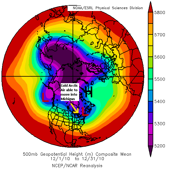
Comparing this December to last December, look at the two images below and compare them to the two right images on our AO diagram above.  Last December we were in a strong negative AO phase.  The first image is 500mb heights (pressure) for December 2010 and the second image is 250mb winds for December 2010.  The 500mb image is nearly opposite of what we saw during December 2010 with low pressure dipping into our area and high pressure near Greenland.  This pattern causes the jet stream to drop below Michigan, allowing the Arctic air to drop into our region as the 250mb image below shows.  With colder temperatures in our region during December, the systems that passed through our area produced mostly snow.

 The above image represents the 500mb heights (pressure) during December 2010.  The darker purple/blue colors represent low pressure while the brighter red/orange colors represent high pressure.  This image is courtesy of NCEP/NCAR.

The above image represents the 250mb winds during December 2010.  The black arrow over the US represent the jet stream.  This image is courtesy of NCEP/NCAR.

Below is another way to show how the differences in the AO phases can impact our temperatures from one winter to the next.


Dec 2010 Avg High – 30.6F
Dec 2011 Avg High – 41.3F (Dec 2011 high is 10.7F warmer)

Dec 2010 Avg Low – 20.7F
Dec 2011 Avg Low – 29.4F (Dec 2011 low is 8.7F warmer)

Dec 2010 Day Avg – 25.9F
Dec 2011 Day Avg – 35.7F (Dec 2011 day is 8.9F warmer)

Note: The day average is (day high temperature + day low temperature) / 2, with the result rounded to the nearest whole value.

All of the above shows why this winter has been so much warmer than last winter.  As a result, when systems have passed through our region, the temperatures were at or above 32F causing mostly rain or a rain/snow mix.  The Metro Detroit region is not alone when it comes to below average snow totals this winter.   Most of the Midwest region is below average, including other parts of Michigan.  For example, Petoskey Michigan has received only 14.2 inches of snow this winter (29.9 inches below average) and Traverse City has received only 4.8 inches of snow this winter (35.4 inches below average).  So far this winter we have 5.6 inches of snow.  I know some of you are saying “what?...I haven’t seen any snow this winter!”.  The 5.6 inches are from the airport in Romulus Michigan where our official records are kept.  Further east in Macomb County, we have received an inch or less of snow.

So is this December a sign of what to expect this entire winter?  Maybe.  I am not sure.  Meteorologists are not able to forecast the AO (or any of the oscillations) more than two weeks in advance so it is hard to predict if the AO will switch to its negative phase any time soon.  There are models that attempt to forecast the AO, which can be seen by clicking here.  This forecast shows models expect the AO to drop to neutral or slightly negative in the next week and then some models have the AO going positive again, while others have the AO going more negative.   Either way, it would be nice if we could get some snow, and for that we would need colder temperatures.  So hopefully it happens soon.

This is my first post since last spring.  Now that winter has arrived again, I will be writing a post each chance we have for accumulating snow and when there is other weather related news worth discussing.  I plan on writing more postings this winter than I did last year so I hope you will check my blog often when there is a snow storm approaching!

Chris