All of southeast Michigan is under a winter storm warning that will start this afternoon at 4pm and will end Monday morning at 7am. This will be a difficult system to forecast largely due to the fact that mix precipitation is expected.
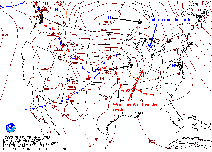
Currently, the center of the low pressure system is positioned along the Nebraska/Kansas border which can be seen on the surface map below. This system is then forecasted to move to the east-northeast into northern Indiana/Ohio on Monday morning. At the same time, a high pressure system that is in central Canada will drift towards the east and be to our north by Monday morning. There a few things that needs to be mentioned with this set up…
Image courtesy of HPC
-The first is the high pressure system with its clockwise flow will cause cold winds at the surface to blow from the north-northeast. At the same time, the low pressure system with its counterclockwise flow will cause low-level winds to blow from the south-southwest with warmer and moist air. What this set up will do is keep the temperatures at the surface at or below freezing during the entire duration of the precipitation. When the warmer and moist air from the south collides with the cold air, it will start to rise over the cold air because colder air is heavier and denser than warm air. This is the reason why we will see mixed precipitation because there will be a layer of air above the surface that will be above freezing while the surface temperature is below freezing. Now how warm and how thick this layer above the surface gets will determine if we will receive sleet or freezing rain (I kind of explained this in my last blog).
-The second thing worth mentioning is that the model runs from this morning seem to favor the center of the low pressure system tracking further south than originally anticipated. Instead of the low tracking through the Michigan/Ohio border, it now appears that it could track further south through northern Indiana/Ohio. What this would do is prevent the warm, moist air from the south from making it as far north as originally forecasted. This would shift all precipitation types further south with snow being the more dominating precipitation type form most people while sleet and freezing rain would remain closer to the Ohio border. If this scenario unfolds, then I would expect the NWS to adjust their forecast to favor more snow for most of southeast Michigan. Other maps including soundings and precipitation type models also seem to favor this shift.
The first map shows the probability of different precipitation types occurring. The map below represents early Monday morning at 1am. It shows that the northern parts of southeast Michigan (top-left image) has the highest probability of snow while the lower half of southeast Michigan (bottom-left and bottom-right images) has a higher probability to see ice pellets and/or freezing rain. This map shows a southward shift of all precipitation types compared to the previous model runs (not shown).
Image courtesy of PSU Ewall
The two images below represent the temperature (red vertical line) and dew point temperature (green vertical line) in the atmosphere from the surface to the top of the troposphere (the atmosphere we live in). I highlighted in black the line that represents the 32 degrees Fahrenheit which is known as the freezing temperature. If the red and green lines overlap each other that indicates that the temperature and the dew point temperature are both the same. If any parts of the red and green lines are to the left of the freezing line then the temperature at that level of the atmosphere is below freezing and to the right represents the temperature is above freezing. Looking at the first image from yesterday morning’s model run, you can see that both the NAM model (to the left) and GFS model (to the right) have a layer of the lower troposphere to the right of the freezing line which indicates that part of the atmosphere will have temperatures above freezing, causing a mix of precipitation since the surface temperature is below freezing. The NAM has the lower troposphere several degrees above freezing than the GFS, but both show mixed precipitation. Now looking at the second image which is from this morning’s model run, the NAM has a much smaller layer above freezing and the GFS has the layer at freezing. This is another indication that we could see more snow than originally forecasted. Both images represent the forecasted conditions of the atmosphere on Monday morning at 1am.

Images courtesy of PSU Ewall
Either way, the precipitation should start out as all snow for everyone in southeast Michigan with the changeover to mixed precipitation starting further south and working its way north Sunday evening. We can expect a lot of precipitation from this system as represented by the 24 hour precipitation total image below which shows southeast Michigan receiving as much as 1.07 inches of precipitation.
Image courtesy of HPC
It also looks like we could have a break from the precipitation during the day on Monday before it picks up again as some models are showing us receiving some snow on the back end of the low as it passes to our south.
Enjoy the winter storm as we might not have many more before spring arrives. It could be a mess if we do receive a long period of time with freezing rain. Click here to go to the NWS Detroit page to see their up to date forecasts. The precipitation is on our door step as shown on the radar image below!
Image courtesy of NWS