Snow is expected in southeast Michigan Tuesday evening into Wednesday morning, but the important question is how much snow can we expect? Let’s look at what is going on in the atmosphere.
In the upper levels, an upper-level low that is currently centered in the northern plains will become negatively tilted as it moves in our direction. There is a shortwave trough that is rounding the base of the upper-level low that will produce a surface low to our southwest. This surface low will travel to the northeast into the Ohio Valley during the day on Tuesday and combine with another surface low that will be moving up the east coast. What we are interested in is how close the surface low will get to southeast Michigan as it passes the area.

Above shows the GFS, NAM, and CMC forecasted position for the surface low as it passes Michigan. The NAM model appears to be the closest to Michigan, which would favor more snow accumulation. The GFS is a little to the east and the CMC is even further to the east over Pennsylvania. So which model appears to be the closest to being correct? It is difficult to say since all three aren’t very far off from each other. Looking below at the current surface map, the surface low is positioned in the northeast corner of Oklahoma. This position could be favorable because the NAM and GFS models have the surface low developing further to the east and the CMC model have the low developing over Tennessee. With the surface low currently further to the west than expected, this could lead to a further westward track closer to Michigan.
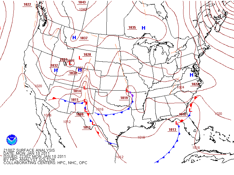
Image courtesy of HPC
So if I had to pick from the three models above, I would favor the NAM with a track that is closer to Michigan. With regards to totals, there are a few issues that could lower the totals somewhat. The first issue is even though the low pressure system will be strengthening as it passes our area, it will not be a very strong system. Another issue is there won’t be a great deal of moisture with this system and there will be a dry layer of air in the atmosphere that will take time to be filled with moisture to allow snow to make it to the ground. The good news is that tomorrow will only make it to about the mid 20s for a high so the traditional 10:1 snow ratio can be adjusted to 12:1 or so. With all of this in mind, I am forecasting a conservative 2-3 inches of snow for the northern suburbs north of Detroit and 3-4 inches south of Detroit. If the low tracks closer to Michigan, these totals will need to be adjusted to higher amounts. Also, the snow is expected to develop around rush hour tomorrow evening, so expect a slow drive home.
No comments:
Post a Comment