Setup
The NWS Storm Prediction Center (SPC) issues convective outlooks several times a day. The purpose is to highlight what parts of the U.S. has an opportunity to see severe weather. If an area has a chance for severe weather, the SPC will issue either a slight, moderate, or high risk. They also give probabilities of that area experiencing severe wind, large hail, and tornadoes. On the morning of March 15th, the SPC gave parts of southeast Michigan a slight risk for severe weather. Their morning convective outlook can be seen here. The probability breakdown was a 5% chance for severe wind, 15% chance for large hail, and less than 2% chance for tornadoes. In short, the primary threat for the day was large hail.
The setup for the day was impressive in some aspects, but not so impressive in others. For an ordinary thunderstorm to develop, the atmosphere needs to have instability, moisture, and a lifting mechanism. For these thunderstorms to have an opportunity to produce a tornado, vertical wind shear is needed as well. On March 15th, there was a southwest flow that brought in warm and moist air from the south that is typical in this area in May or June. Because of this, there was a good amount of instability and moisture in Michigan. Temperatures were able to climb to the mid to upper 70s with the dew point temperature ranging from the upper 50s to low 60s. The image below represents the instability and moisture at 2pm. Read the caption below to better understand what each image represents.

All images courtesy of NWS SPC
Top Left - CAPE Convective Available Potential Energy. Indication of instability. Values were above 2000J/kg. Values over 500 J/kg (or even less) are capable of producing thunderstorms.Top Right - Surface dew point temperatures in the upper 50s to low 60s. Indication of moisture.
Bottom Left - Low-level lapse rate. Indication of instability. Values higher than 6C/km is high, values ranged from 6-7.5C/km
Bottom Right - Mid-level lapse rate. Indication of instability. Values higher than 6C/km is high, values were around 8C/km
What was not so impressive was the lifting mechanism and vertical wind shear. A lifting mechanism is needed to get the air parcels near the surface to start rising vertically. If the air parcels are able to get to their level of free convection (LFC), then they will be able to rise freely through the atmosphere until they reach their equilibrium level (EL). This is how a thunderstorms updraft is formed. The faster the air parcels are able to rise, the stronger the updraft can become. Upper-level waves and surface boundaries (example cold front) are features that can cause lifting. The lifting mechanisms in place on March 15th were a weak upper-level shortwave coming from our south and a weak area of low surface pressure with a cold front approaching from our west. Since these features were rather weak, there was a question as to whether or not they would be enough to get the air to rise to their LFC, but with the impressive instability and moisture in place, thunderstorms were expected to form. I will discuss the wind shear a little later.
Just before 4pm, the NWS SPC issued a mesoscale discussion which can be seen here. A mesoscale discussion is basically a notification that conditions are becoming favorable for severe thunderstorms and that a watch may need to be issued. At 430pm, they issued a severe thunderstorm watch for all of southeast Michigan. The watch information can be seen here.

Severe Thunderstorm Watch for Southeast Michigan. Image courtesy of NWS SPC.
When a watch is issued, just like with convective outlooks, they give probabilities of certain severe weather occurring. They gave 30% chance of severe wind, 50% chance of large hail, and most importantly, only a 10% change of tornadoes (with a 5% chance of a tornado EF2 or stronger). This tornado probability for a watch is rather low. The reason the tornado potential was low was because the vertical wind shear wasn't very strong. Wind shear is a change of wind direction and/or wind speed with height. Wind shear is what puts a spin in the atmosphere that can cause a thunderstorm to start rotating. If a thunderstorm starts rotating, it will be classified as a supercell (if it has a well defined rotating mesocyclone for 10 or more minutes) and have a chance to produce a tornado. The reason the wind shear wasn't very strong was because the upper level jet stream was well to our north in Canada and there were no large upper level systems nearby. These are the primary factors that usually cause high wind shear. So when the severe thunderstorm watch was issued, a tornado forming was not a very high concern.
Thunderstorm Development
The first signs of thunderstorms developing occurred in mid Michigan around 3pm. Thunderstorms were able to form due to an outflow boundary (from morning thunderstorms in northeast Ohio) clashing with east/northeast winds coming from the area of low pressure to our west. The visible satellite image below shows this process occurring. This image is from 1232pm.

Visible satellite image of Michigan. Image courtesy of DuPage college.


To read more information about these tornadoes, you can read the NWS Detroit/Pontiac office summary here.
An outflow boundary (which is a surface boundary) is rain cooled air that moves away from a thunderstorm. A thunderstorm will produce a downdraft of rain and sinking air. When this air hits the ground, it has to move horizontally out away from the storm. If the downdraft is strong enough, its outflow boundary can travel for hundreds of miles, and if it interacts with another surface boundary, can cause new thunderstorms to form. This is exactly what happened. The image below shows this process occurring. It has four visible satellite images at 1232pm, 145pm, 315pm, and 432pm. You can see the boundaries separated in the first two images, the third image shows cumulus clouds forming from the rising air caused by the collision of the two boundaries, and the forth image shows thunderstorms in progress.

Visible satellite images of Michigan. Image courtesy of DuPage college.
Once the thunderstorms were able to form, they had plenty of warm, moist air to feed on to help them grow. The radar image at 344pm below shows the first thunderstorm that was able to develop. This was the thunderstorm that later went on to produce two tornadoes, including the EF3 tornado that went through Dexter Michigan.

Radar image at 3:44pm of thunderstorms starting to develop. Image courtesy of Plymouth State Weather Center.
Thunderstorms continued to develop in a line north to south along the line of convergence where the two surface boundaries met.
Supercell 1 – Tornadoes 1 and 2
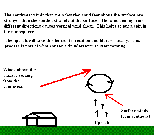
The first thunderstorm quickly developed into a supercell as it moved to the east. By definition, a thunderstorm is considered a supercell if it has a rotating mesocyclone (midlevel rotation) for more than ten minutes. As mentioned earlier, there needs to be sufficient wind shear in order for a thunderstorm to develop a rotation. I also mentioned earlier that the wind shear was weak and the NWS SPC didn’t expect there to be enough wind shear to produce a tornado, so what happened? I suspect that the outflow boundary helped produced the needed wind shear to cause thunderstorm rotation. I think this because the outflow boundary was moving to the northwest helping produce winds from the southeast at the surface ahead of the thunderstorms. The winds above the surface were coming from the south to southwest. This change in direction with height was enough to increase the wind shear and storm relative helicity to cause rotation. The image below gives an illustration example to this process.

Diagram shows effects of vertical wind shear. Image courtesy of myself.
Giving credit where credit is due, in an updated forecast discussion on March 15 at 12:42pm, the NWS Detroit/Pontiac office did notice the change in surface winds to a more southerly direction, and had this to say:
“ONE CHANGE FROM THIS MORNING...FLOW IN THE LOWEST LEVELS HAS TURNED MORE SOUTHERLY...INCREASING LOW-LEVEL DIRECTIONAL SHEAR. CANNOT THEREFORE RULE OUT A SUPERCELL OR TWO.”
Looking at the radar 45 minutes later at 430pm, you can see more thunderstorms developing, along with the strengthening of the thunderstorm that turned into a supercell.

Radar image at 4:29pm of thunderstorms. Image courtesy of Plymouth State Weather Center.
By 515pm, the main thunderstorm developed into a classic supercell and was tornado warned. A supercell can be tornado warned if the Doppler velocity radar detects strong rotation, meaning that a tornado can form at any time, or if a tornado is spotted on the ground and someone calls it in to the NWS. The image below is a close up of the supercell at 515pm.

Close up of radar image at 5:15pm of a supercell. Image courtesy of Plymouth State Weather Center.
The next image below is a diagram that on the left represents the “text book” look of a classic supercell and on the right shows features of a supercell such as the location of the mesocyclone and the hook echo. Notice how the supercell on the radar image above looks nearly identical to the diagram of a classic supercell below.

Diagram of classic supercell thunderstorm. Image courtesy of PSU.
The next image below is a close up of the Doppler velocity radar at the same as the radar image above. In short, the Doppler velocity radar shows wind direction and wind strength. The wind direction is relative to the physical location of the radar, which is in White Lake Michigan. This is useful in detecting rotation in a thunderstorm, which is used to issue a Doppler radar indicated tornado warning.

Dopper velocity radar a t5:15pm. Image courtesy of Plymouth State Weather Center.
Look at where I put in yellow arrows. The yellow arrow on the left, where you see red/brown color indicate winds moving away from the radar and the yellow arrow on the right, where you see green, indicates winds moving towards the radar. When you have winds moving in opposite directions right next to each other, this represents rotating air which means the mesocyclone has a rotation. The stronger the winds, the stronger the rotation. This does not mean that a tornado is on the ground but it does mean that a tornado can form at any time. As I mentioned, the radar images are from 515pm, at 517pm, the first tornado was reported near Pickney Michigan in Washtenaw county.
Due to its rotation, the supercell went from an easterly direction to a southeast direction. At 650pm, the second tornado from the same supercell was reported in Ida Michigan in Monroe county. The radar image below is at 645pm. Note that the supercell doesn’t look the same as it did above. This is because it merged with another thunderstorm while moving towards Monroe county. This most likely started its weakening phase, but it was still strong enough to produce a tornado.

Radar image at 6:45pm of thunderstorms. Image courtesy of Plymouth State Weather Center.
Supercell 2 – Tornado 3
Another supercell formed to the north of Flint Michigan and as it moved to the southeast, it produced a tornado near Columbiaville Michigan in Lapeer county. This tornado was first reported at 649pm which means it was on the ground at the same time as the Ida tornado. The radar image above also shows the supercell that produced this tornado. It was a brief tornado but was able to do some damage.
More information on the Tornadoes
The first tornado started near Pickney Michigan at about 517pm and moved to the southeast. It was classified as an EF3 tornado with maximum wind speeds of 135-140mph. This tornado was 800 yards wide (2400 feet, nearly ½ mile) and was on the ground for 7.2 miles. It hit its peak strength when moving through a suburb in Dexter Michigan causing major damage to many homes. The image below shows the path of this tornado.

Path of the 3/15/2012 tornado that occurred near Dexter, MI in Washtenaw County. Image courtesy of NWS Detroit/Pontiac.
The next image is a picture of the Dexter tornado.

Screenshot from footage taken at Hudson Mills Metropark. Matthew Altruda/Youtube. Image courtesy of NWS Detroit/Pontiac
The second tornado was a shorter lived tornado that formed in Ida Michigan. This tornado was an EF0 with maximum wind speeds of 85mph. The width of the tornado was 50 yards (150 feet) and it was on the ground for ½ mile. The image below is of the Ida tornado.

Monroe County Tornado. Photo by Joey Wherry. Image courtesy of NWS Detroit/Pontiac.
The third tornado formed 3 miles south of Columbiaville Michigan. It was rated an EF2 with maximum winds of 125mph. Its width was 400 yards (1200 feet) and it was on the ground for 4.5 miles. The image below shows its path.

Path of the 3/15/2012 tornado that occurred near Columbiaville, MI in Lapeer County. Image courtesy of NWS Detroit/Pontiac.
To read more information about these tornadoes, you can read the NWS Detroit/Pontiac office summary here.
March 15th was a very unusual day for Michigan. We do not usually get severe weather outbreaks this early in the year. In fact, this was the earliest in the year that an EF3 tornado has occurred anywhere in Michigan. Also, March 15th ranks as the second earliest date where multiple tornadoes occurred on the same day in Michigan. The earliest was on March 12, 1976 when eight tornadoes touched down in Michigan. In some ways, we can be considered lucky that this is all that happened. If there was a stronger upper level wave nearby and the jet stream was over our region, which both are typical for spring storms, then we would have had plenty of lift and wind shear. This most likely would have produced many more tornadoes.
No comments:
Post a Comment