Southeast Michigan experienced its first snowstorm of the winter this past weekend. Snow totals varied greatly depending on your location. The map below (provided by the NWS) shows that totals ranged from less than 4 inches near the Ohio border to more than 14 inches in the thumb. In fact, it was reported that between 18-22 inches of snow fell in Harbor Beach and Port Hope Michigan in Huron County. Even more amazing is that wind gusts of 50mph caused snow drifts as high as 14 feet!
The snowstorm itself was a pretty average December storm. The precipitation started as rain for the first several hours and then switched over to snow, producing several inches. The not so average part came the next day when Huron and Sanilac counties were both under a blizzard warning. So how did this happen and why did they experience the worse a day after everyone else had their snowstorm?
The image below can help answer those questions. This image represents the surface pressure and surface wind for Monday December 13th at 7am. The surface low that brought the snow is now to the northeast over Quebec, but its effects were still being felt in Michigan. This is because low pressure systems have a cyclonic flow that causes the winds to go in a counterclockwise motion. This counterclockwise flow can extend several hundred or more miles from the center depending on the strength of the low pressure system. With Michigan to the west/southwest of the low, we experienced winds coming from the north/northwest (the black arrow represents the general wind flow). Winds from this direction was why there was very cold arctic air brought down from Canada in the early part of the week. So with a north/northwesterly wind that was very strong (can be seen with the tightly packed isobars), combined with other favorable conditions that I hope to explain in a future blog, lake effect snow bands were able to set up over the northeast tip of the thumb.
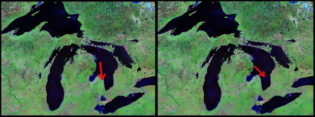
The winds having more of a northerly flow instead of a northwesterly flow was the difference from the snow bands setting up over land instead of over water. The image below on the left shows that a northerly wind over Lake Huron will cause lake effect snow over land, but as the image on the right shows, if the wind flow was more northwesterly, the snow bands would set up off shore and over Canada.
That explains why the thumb received more snow, but not why they had blizzard warnings that produced snow drifts up to 14 feet. The reason for this also has to do with the wind direction. Since the winds are more northerly, they traveled a pretty good distance over Lake Huron. Wind that travels over water has less friction to deal with and because of that are able to maintain higher speeds. This is why they experienced gusts up to 50mph. On the other hand, wind that travels over land has a lot more friction (trees, buildings, etc.) to slow it down, and that is why everywhere else experienced wind conditions below blizzard standards.


No comments:
Post a Comment