Wednesday, January 18, 2012

Finally…accumulating snow is in the forecast!


Some people in Southeast Michigan have already had accumulating snow this winter, but the people living in the eastern portions of Macomb County have seen pretty much no snow at all.  The good news is that the models are showing that we could get accumulating snow Friday evening into Saturday morning!  However this isn’t a sure thing because, as usual, there are still uncertainties to deal with.  The different models agree on the basics but not on the exact path/strength of the system.  This plays a big role on who gets what.  Considering the fact that the system that could bring us snow is still near Alaska, it is no surprise that the models do not agree this far out.  Anyways, below are a few images of what is being forecasted as of this afternoon.  As it gets closer and the models begin to converge on a solution, I will write another posting with more information.

 Image courtesy of PSU eWall.  Click to make image bigger.

The above image represents the upper level system (upper left image), the surface low (upper right image), and the 6-hour precipitation totals (lower right image).  This image is from the NAM model…I selected the NAM model because it was the most aggressive with snow totals.  However it does represent a few concerns…one being that the NAM has the upper level system much stronger than the other models.  Another issue is the NAM is forecasting the track of the surface low pressure system to be a little further north which can cause warmer air into our area and change the snow over to a mix precipitation or possibly rain.  Click on the image to make it bigger.
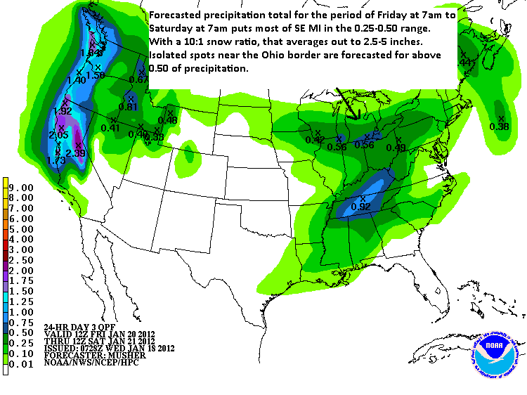

Image is courtesy of HPC.

The second image represents the forecasted precipitation total for a 24 hour period beginning on Friday at 7am and ending on Saturday at 7am.  Most of SE Michigan is between 0.25 and 0.5 inches of precipitation, and if we use the average 10:1 snow ratio, that is about 2.5 to 5 inches of snow.  That range sounds correct given most forecasts are showing 2-4 inches.  You can see that there is an area near the Ohio border that is forecasted to receive above 0.5 inches of precipitation.
 
 Image courtesy of HPC

The final image represents snow probabilities for the same 24 hour period as the image above.  It gives SE MI a 10% chance of receiving 4 or more inches between Friday morning and Saturday morning.  I know 10% sounds low but as I said earlier, due to the fact that the system is still thousands of miles away from Michigan, it wouldn’t make much sense to go a lot higher at this point.

I didn’t proofread this posting so if there are a lot of typo’s…oh well.

Chris

Thursday, January 12, 2012

Snow? What snow?

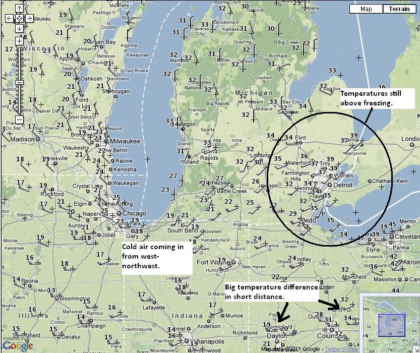
It is almost 9pm on Thursday evening, and taking a look at the local temperatures, it is still above freezing in most of the Metro Detroit area.  The map below shows current temperatures for Michigan and its surrounding states.  You can see that the temperatures in the circle are in the mid to upper 30s, but if you look to the west from the Lansing area to Lake Michigan, temperatures range from the low to upper 20s.  Even further west the temperatures are in the upper teens.  This shows that pretty cold air is moving into our area which will change any rain to all snow most likely sometime before midnight.  By looking in central Ohio you can get a good idea on where the cold front is.  The temperature in Columbus Ohio is 31F but the temperature in Dayton Ohio is 20F.  That is a 11F difference in about 70 miles.  So it is easy to see that the cold air is making its way into southeast Michigan.

 The image represents current temperatures.  Click on the image to make it bigger.  Courtesy of NWS.

Looking at the radar below, most of the precipitation is to our west and north.    Also, the center of the low pressure system is currently positioned in southeast Michigan.  The center of the low being positioned in our area is bad for the following reason.  The air around the center of a low pressure system moves in a counterclockwise direction.  If you look at the radar, you will see this by watching the precipitation move counterclockwise.  With mature storm systems like this one, dry air from higher levels start to sink on the western edge of the upper level wave, and as it sinks, it gets caught up in the counterclockwise circulation.  This causes the drier air to move towards the center of the low pressure system, which is in southeast Michigan.  The term for this is a dry slot.  This dry slot is strong enough to prevent precipitation from forming and that is why it is not raining or snowing right now.  The center of the low pressure system will eventually move off to the east, bringing in colder and moist air behind it, but this is not expected to occur until around sometime after midnight.  Because of this, we can expect even lower totals for the Metro Detroit area.  I would guess around an inch if we are lucky.  Further north from about Saginaw towards Midland, the dry air will move in but it won’t last very long.  Therefore, they are expected to get 3-5 inches of snow.  Towards Lake Michigan, they can get 6-12 inches.  

 This is the current radar.  Courtesy of NWS.

One last thing…below is a good example of the bubble.  There are winter storm warnings and winter weather advisories in the entire Great Lakes region except for southeast Michigan.  This is what the bubble does.  It blocks snow from reaching where I am.

 This image represents the bubble.  Courtesy of NWS.

The bubble isn’t a real weather term, but sometimes I think it is.  Only one or two people will know what I am talking about!

Chris

Wednesday, January 11, 2012

Snow in the Forecast for Thursday Night into Friday


Well it looks like the Metro Detroit area will finally receive some accumulating snow Thursday night into Friday!  The current forecast is for the precipitation to start as rain during the day on Thursday, and then once temperatures are able to drop below freezing, the precipitation will have a chance to turn into snow.  As of this evening, the general consensus appears to be 1-3 inches, with the higher amounts most likely occurring the further west you go into central Michigan.  There will be a lot going on during the next 36 to 48 hours so the forecast could change slightly either way.  Let’s take a look at what we can expect.

Currently there is a low pressure system with its center in Kentucky moving to the northeast towards New England.  As the system gets closer to Michigan tomorrow morning, the low pressure will go through a process known as occlusion.  This will cause another surface low to drift to the north into Lower Michigan.  This will cause warmer air to move into the Metro Detroit area during the day on Thursday, with temperatures reaching the lower 40s.  This will cause the first wave of precipitation to be all rain.  The weather map below shows the forecast for Thursday morning.

 The image above is courtesy of HPC.

Right behind this occluded low will be another low pressure system coming from the northwest.  This system will help push the occluded low off to the east while bringing in colder air behind its cold front.  Once the cold front passes, cold air will rush in behind it allowing the temperatures to drop below freezing.  The timing of when this will occur is expected to be Thursday evening around 10pm to midnight.

 This image represents the forecasted surface temperatures for Thursday evening at 10pm.  It shows that below freezing temperatures will be in the northern portion of southeast Michigan indicating any precipitation falling would start turning over to snow.  You should be able to click the image to make it bigger.  This image is courtesy of PSU ewall.


So it doesn’t look like we can expect a lot of snow with this system but considering that we haven’t received any snow yet, I sure will take it.  The good news is that the second system will have good dynamics which could help increase our snow totals.  This won’t really be known for sure until a few hours before the snow starts.  This type of forecasting is called nowcasting.  I will be doing this as the snow approaches, so if anything changes, I will let you know.

Chris